New seismic surveys fine-tune the picture
Starting on 7 September, two further seismic surveys will be carried out simultaneously in the search area and its wider surroundings for the Einstein Telescope. As with previous surveys, including those conducted this spring, the aim is to map noise and vibrations that could affect the operation of the Einstein Telescope. Seismic surveys also provide information about the composition of the ground at greater depths.
Seismic research is part of the feasibility studies for the Einstein Telescope. The aim is to build the Einstein Telescope at a depth of 250 to 300 metres below ground in the border region of the Netherlands, Belgium and Germany.
Thirty municipalities
Following the surveys carried out last spring, around 550 geophones will be installed for approximately 30 days in 30 municipalities across Wallonia, German-speaking Belgium, Belgian and Dutch Limburg, and the Aachen region in Germany.
Geophones are small seismometers that detect these vibrations. This makes it possible to record environmental noise from sources such as industry, flowing water in streams or railways, and compare it with locations where deep drilling has previously been carried out.
Agreements have been reached with the municipalities and the owners of the sites where one or more geophones will be installed regarding permission and the duration of the survey. No special traffic measures are required, and the survey will not cause any disruption.
The survey is being carried out on behalf of the Einstein Telescope Project Office by the University of Liège, the Royal Netherlands Meteorological Institute (KNMI) and RTWH Aachen.
Driving along the survey routes
At the same time, another type of seismic survey will be conducted in a small part of the rural areas of the municipalities of Plombières, Welkenraedt, Gulpen-Wittem, Dalhem and Herve.
During this survey, a small tractor equipped with seismic electrical measuring equipment will travel along a designated route, sending vibrations into the ground in the low-frequency (Hertz) range. Geophones equipped with sensors along the route will record the reflection of these vibrations. The geophones will be temporarily installed along the route and collected again after the measurements.
‘Sweep’
During the survey, the geophones will be installed manually. The tractor equipped with the measuring equipment (see photo) will then carry out the measurements. To do so, the tractor will make short stops to send vibrations into the ground. Each of these stops, or “sweeps”, will last approximately one minute on average. The tractor will then move about four metres further along the route before making the next stop.
Measurements in the municipalities of Plombières, Welkenraedt and Gulpen-Wittem will be carried out during the day, while measurements in Herve and Dalhem will take place at night.

Information letter
The survey consists of routes averaging several kilometres in length. The geophones will be collected after each route, their data will be read out and the devices will then be cleaned. They will subsequently be used again on the next route.
The total survey route covers 12 km. Residents living along the route have been or will be informed about the survey in good time by letter. The survey is being carried out by Faraday Geophysics.
The geophone
Different types of geophones will be used for the two surveys.
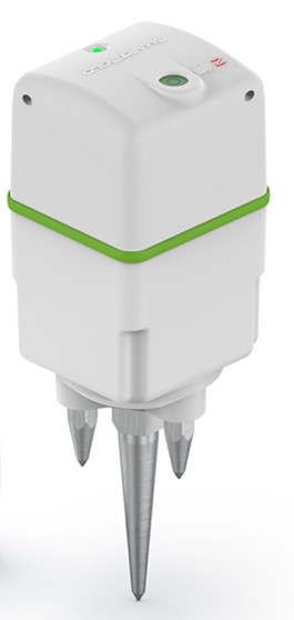
For the 550 geophones that will measure noise for 30 days, the devices consist of small, compact plastic boxes measuring 10 by 10 centimetres, with a built-in noise meter. The devices do not produce any sound or transmit any signals. A very small LED light on the top indicates whether the geophone is operating.
The geophones will be buried approximately 15 centimetres underground. After three to four weeks, they will be removed and the holes will be filled in again. Their presence will have no impact on the use of the land during this period. The overall impact is virtually negligible.
The geophones used during the survey involving the tractor and measuring equipment that generates vibrations in the ground are even smaller, measuring 10 by 4 centimetres. They will only be used once at each location and will be collected no more than a few days after the “sweep”.


